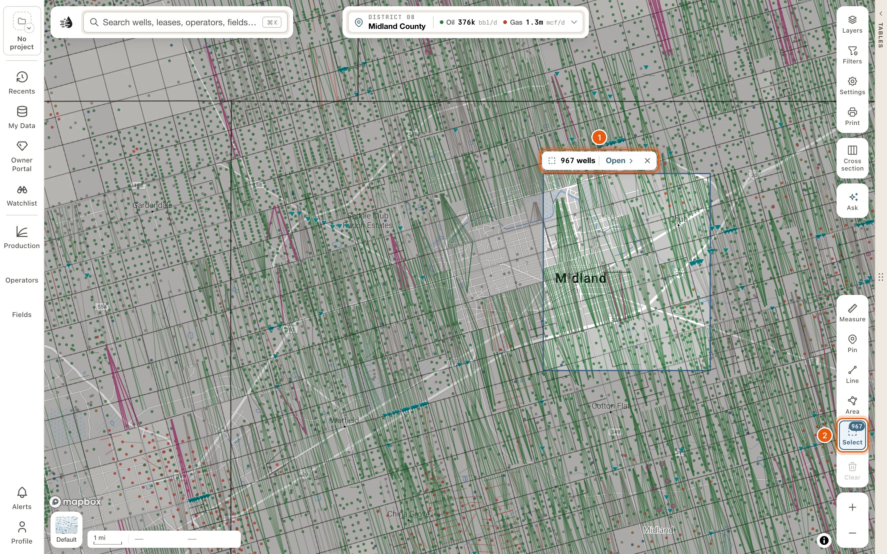
- The Select tool is there for everyone.
- The card opens with a paid plan. Without one, you’ll be asked to sign in or choose a plan.
Select an area
1
Turn on Select
Click Select in the draw tools at the bottom right of the map, or press S. On a short map the tools are folded into Draw: click it, then Select.A bar at the bottom of the map says what to do next.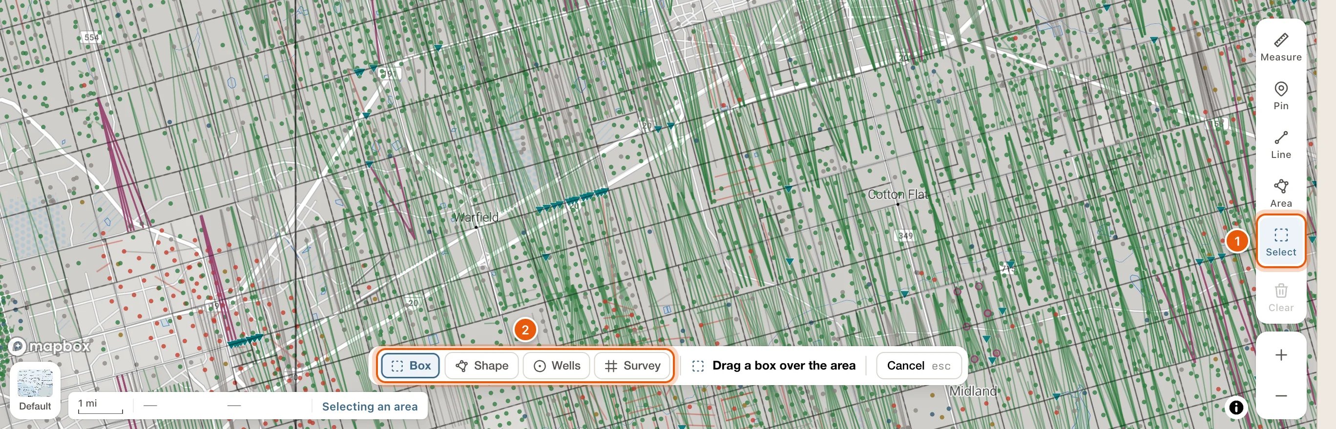
2
Choose how to select, and select
The bar’s first buttons say how:
- Box: drag a box over the area. Its size rides beside the pointer, such as 1.5 × 1.4 mi · 1,344 acres.
- Shape: click to place each corner. Double-click, or click the first corner, to finish. Undo corner takes the last corner back.
- Wells: click wells to pick them, and click one again to drop it. Click Done when you have them all. The selection is exactly those wells.
- Survey: click tracts of the original Texas land survey, then Done. If the bar says Zoom in to see the survey grid, zoom in until the tracts are drawn.
3
Read the card
The Selected area card opens as soon as you finish. The map keeps the outline, and the rest of the map is dimmed.
What counts as inside
- Wells: a well is in when its surface location is inside the area, or when its horizontal lateral, as the map draws it, crosses into the area. This works at any zoom, with no limit on how many wells.
- Leases: those with one of the area’s wells on them, and those whose centre is inside the area.
- Fields are the fields of the area’s wells, frac jobs those on its wells, and P-4 transfers those of its leases.
The Selected area card
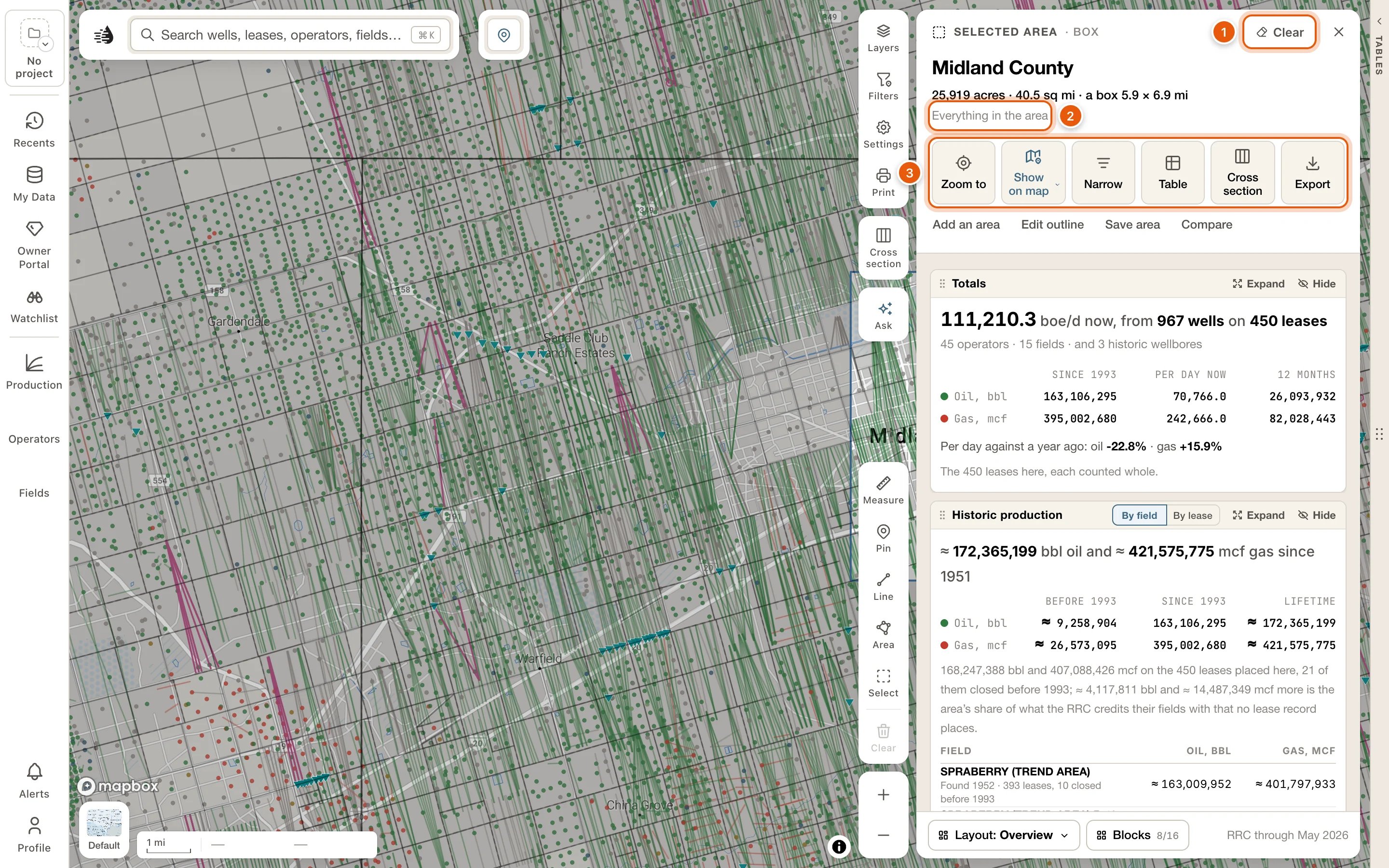
- Selected area and the kind: Box, Shape, Wells, Tracts, or Joined for one put together with Add an area.
- Clear takes the selection away: the outline, the card and its tab. ✕ only closes the card, and the selection stays on the map.
- The title is the counties the area’s wells are in, most wells first. Survey tracts are named instead, such as Sections 22, 27 · Blk 39 T1S · T&P RR CO, and picked wells read like 3 wells you picked.
- Its size, in acres and square miles.
- The narrowing line: Everything in the area, or what you’ve narrowed it to, such as 19 of 117 wells followed by your choices and Clear.
- Zoom to fits the map to the area.
- Show on map sets how the area is drawn. See Show it on the map.
- Narrow narrows the selection. See Narrow the selection.
- Table lists the area’s rows in the data tables. See Its rows in the data tables.
- Cross section puts the area’s wells in a cross section, ordered along the area’s longer side. With more than 30 wells, you pick 30 of them: the section’s picker opens with Pick up to 30 of the 412 wells in the area.
- Export writes the area’s wells, production, land grid and tables as files for your own software, in one zip. See Export.
The blocks
Every figure on the card is the area’s own. Production comes from the area’s leases, each counted whole.
More blocks are in the card’s Blocks list: Fields, New wells, Type curve, Frac, P-4 transfers, Valuation (needs the lease valuation add-on), Formations and Documents. Blocks and Layout are at the foot of the card; see Record cards for how blocks are arranged.
Point at a row in a well, lease or operator list and the map lights it. Compare the top 3 in Operators, By lease and Fields puts the biggest ones in the compare tray. Show all N in the table lists them in the data tables.
Narrow the selection
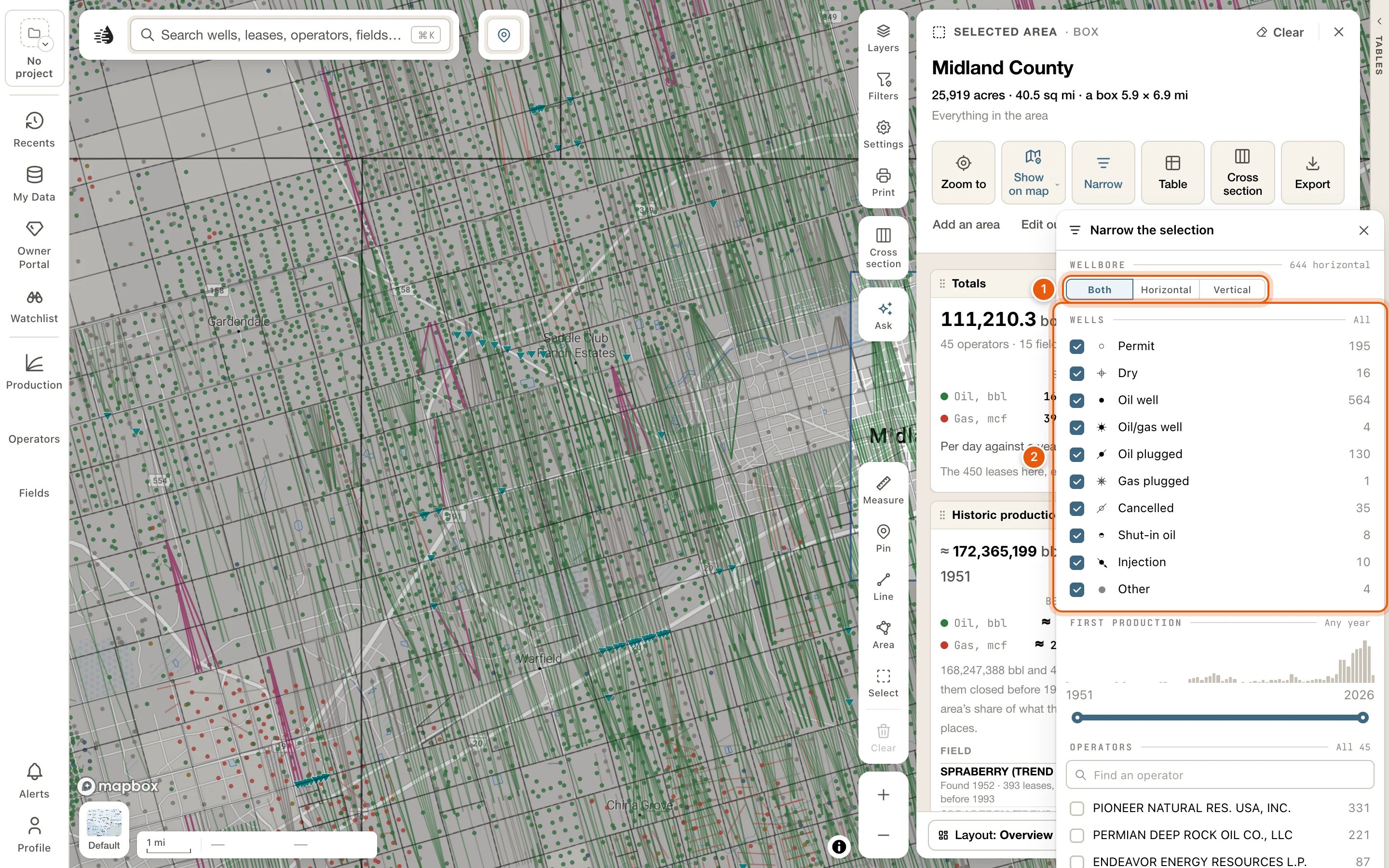
Narrow opens Narrow the selection:- From your map: the map filter the box took in, with Remove. It’s only there when your map was filtered.
- Wellbore: Both, Horizontal or Vertical.
- Wells: the area’s wells by their map symbol, each with a count.
- First production: a range of years.
- Operators and Fields, each with a search box.
Show it on the map
Show on map has three switches:- Outline: the area’s edge.
- Dim the rest: the map outside the area, faded.
- Only matching wells: after you narrow, draws only the wells that match. Every other well leaves the map, around the area as well as inside it.
Its rows in the data tables
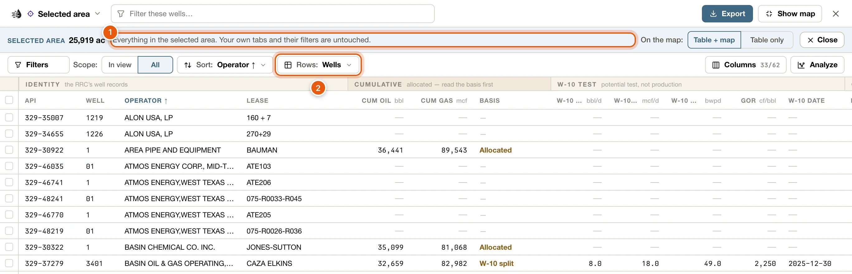
Table opens the Selected area tab in the data tables. It works like a Record tab:- The band says Everything in the selected area. Your own tabs and their filters are untouched. For picked wells it says Every well you picked., and a narrowed selection says how far, such as 19 of 117 wells, narrowed on its card.
- Rows switches between the area’s Wells, Leases, Operators, Fields, Frac jobs and Transfers.
- On the map: Table + map shows only the rows’ wells or leases on the map while you’re on the tab. Table only leaves the map as it was.
- Close ends the tab. Your own tab comes back as you left it.
Export
Export opens the Export card. Each kind of data the area holds is on a row of its own, with how many there are and a button for each format: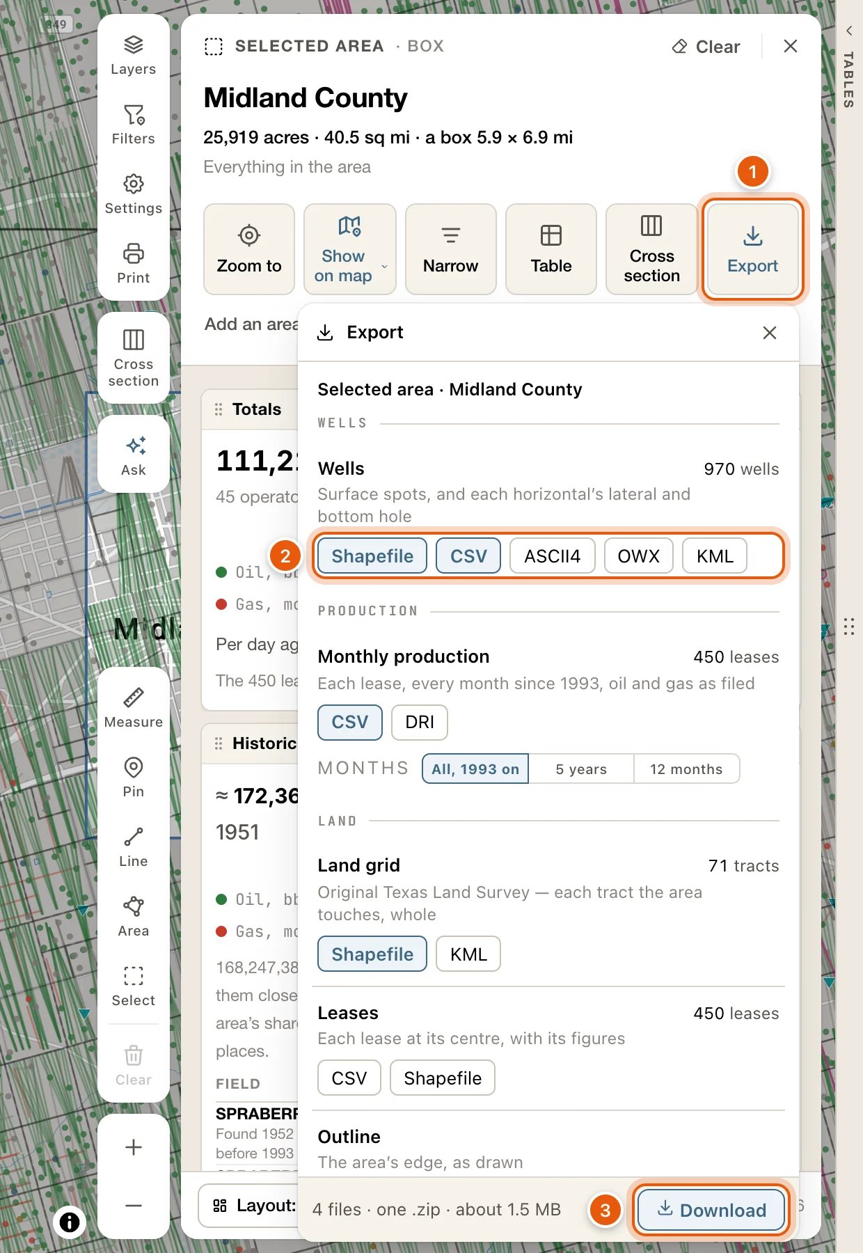
README.txt that says what each file holds. There’s no limit on how many wells or leases. A narrowed selection exports the wells you narrowed it to, and their leases, while the land grid and the outline are the whole area’s. Wells you picked one by one have no outline.
You can close the card while the files are written: a row at the bottom of the map says how far along the export is, with Open and Cancel. See Export an area or a county for what’s in each file, the coordinates they use, and what to do if an export stops.
Add, reshape, save and compare
- Add an area: what you draw or pick next joins this selection. The bar says Adding to the selection. Press it again, or Esc, to stop.
- Edit outline: drag a corner, or drag a midpoint to add one, then click Done in the bar at the bottom of the map. Picked wells have no outline to edit.
- Save area: give the area a name and click Save. Open it again from Saved in Select’s bar. Once saved, the button reads Saved as name, and it lets you Rename it, Update it with the narrowing you have now, or Delete it.
- Compare: puts the area in the compare tray, to set beside other areas.
Come back to it, or clear it
There is one selection at a time. A new one replaces it. The selection stays on the map when you close its card, and it’s still there the next time you open Maps. To open the card again:- click inside the area on the map,
- click Open on the tag at the top of its outline (the tag shows its well count), or
- click Select, which shows the well count while the card is closed, or press S.