

On the well card
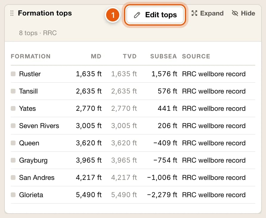
A well’s card lists its tops under Formation tops, shallowest first. The note beside the heading counts them, like 9 tops · 2 yours.
The footer says once where subsea is measured from, such as Subsea from KB 2,914 ft · RRC filing, and when TVD is taken as MD for want of a survey.
Click Edit tops to add or change your tops. A well with none has Add a top instead. See Edit tops on a well.
Map a formation
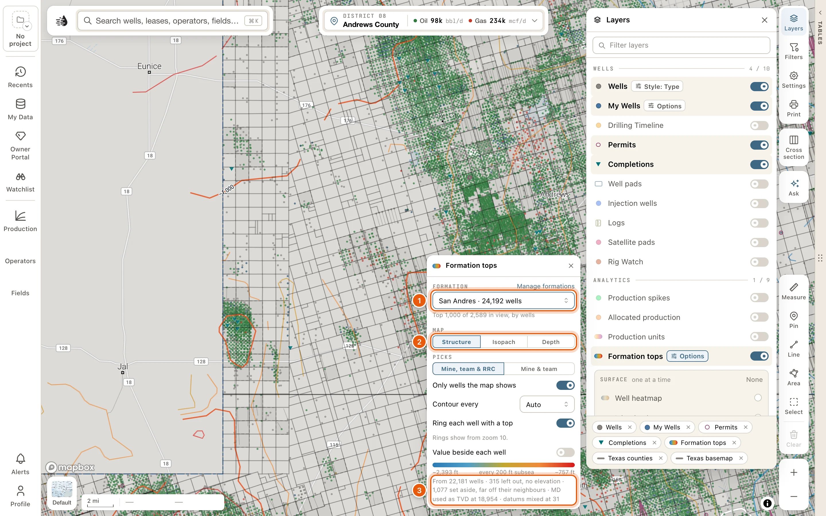
The Formation tops layer contours one formation from the wells in view: how deep it lies, how thick it is, or its depth from the surface.- Click Layers on the right side of the map, and turn on Formation tops in the ANALYTICS group.
- Click Options on its row, and choose the formation under FORMATION. The list holds the formations picked in the wells in view, most wells first, such as Wolfcamp · 1,204 wells. Type to find one.
- Under MAP, choose what the lines show:
- Structure: the top’s depth below sea level (subsea).
- Isopach: the thickness from this top down to a second formation, which you choose in Down to….
- Depth: the top’s true vertical depth.
The other choices
- PICKS: Mine, team & RRC uses every pick. Mine & team leaves out the RRC’s, for a map of your organization’s work alone.
- Only wells the map shows: on at first. It uses only the wells your filters leave on the map. Turn it off to use every well in view.
- Contour every: Auto, or a fixed spacing from 10 to 500 ft.
- Ring each well with a top: on at first. Turn it off to see the contours alone.
- Value beside each well: writes each well’s value beside it, from zoom 13, in a spot your well labels leave empty. Point at one for the well’s name.
- Manage formations opens your formations in My Data. See Your tops and formations in My Data.
The legend
Under the choices, the colour ramp gives the lowest and highest values, and the spacing of the lines, like every 50 ft subsea. A line under it says what the map was built from, such as From 412 wells · 38 left out, no elevation · MD used as TVD at 61. Wells with no elevation can’t give a subsea value, and wells with no survey use their measured depth as TVD. When there’s nothing to draw, the panel says why:- Pick a formation to contour.
- Pick the formation to measure down to. for Isopach.
- Fewer than 3 wells in view have a Wolfcamp top to contour. Zoom out, or turn off Only wells the map shows.
- Every Wolfcamp value in view is the same: nothing to contour.
Edit tops on a well
Correcting a well’s tops needs a paid plan. Open the tops editor from:- Edit tops (or Add a top) under Formation tops on the well’s card.
- Edit tops where the well’s popup lists its tops.
- Edit on the well’s card or popup, then the Tops tab.
- A well in a formation’s list in My Data. See Your tops and formations in My Data.
1
Check where your depths are measured from
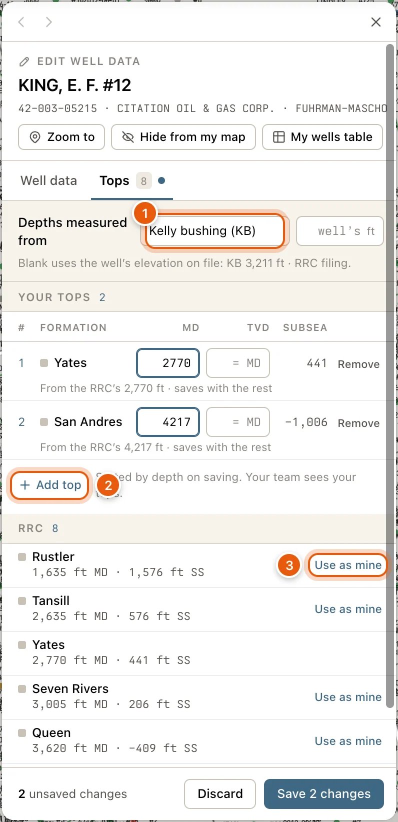
Depths measured from is your tops’ datum: Kelly bushing (KB), Derrick floor (DF) or Ground level (GL). Beside it, type that datum’s elevation in feet, or leave it blank to use the elevation QuickScout has on file for the well. The line underneath says which, and how subsea is worked out.
2
Add or change your tops
Under YOUR TOPS, each of your tops is a row: #, FORMATION, MD, TVD and SUBSEA.
- Add top adds a row. Pick one of your formations, or type a new name, then its MD.
- Leave TVD blank to work it out along the well’s survey, or to use the MD when the well has no survey.
- SUBSEA is worked out as you type.
- Remove takes a top off when you save. Taken off on saving lists what will go, and Undo keeps them.
3
Copy the RRC's tops if you agree with them
The RRC list, below your team’s, has the Railroad Commission’s tops. Use as mine on any of them adds it to your tops at the RRC’s depth. Change the depth before saving if you need to.
4
Save
Click Save (it counts your changes, like Save 2 changes), or press Enter in any box. Discard throws your changes away. Your tops are sorted by depth when they save, and your team sees them.
- What’s missing: Pick or type a formation, Enter the MD.
- What can’t be right: TVD cannot be deeper than MD.
- What’s worth a look: Below the well’s TD, or the same formation picked twice.
- Otherwise, the other picks of the formation (Also RRC W-2 7,412 ft) or where yours came from: Picked on a log, Picked on the map or Imported from a file.
Your tops and formations in My Data
Open My Data on the left rail, and click Open on the Formation tops: your picks and your formations row. Choose between two lists, Picks and Formations. My Data is part of the paid plans.Picks
Every formation you or your team has picked, most wells first. Each row counts the wells with a pick, and how many are yours and your team’s. Click a formation to list its wells, each with the pick’s MD, FT and SUBSEA, FT and whose pick it is. Click a well to open it in the tops editor; its back button brings you back to the list. Above the list:- Show on map contours that formation with the Formation tops layer. Press it again to turn the layer off.
- Zoom to frames every well listed, not only the page on screen.
- Edit formation opens the formation, when it’s one of yours.
Formations
Your formations are the names and colours your tops show by, wherever you see them. Find a formation, yours or the catalog’s… narrows the list. Click one of yours to change it:- Name and Colour. With no colour picked, the map gives it one.
- Stage or age and Basin.
- Other spellings: names in RRC filings or your files that mean this formation, separated by commas. Their tops show as this one.
Other places to pick tops
- On the cross-section, Pick tops places and drags tops on several wells side by side.
- On a log, Pick tops in the Log tab places a top where you click the log.
- Importing scout tickets, or a table with formation tops, in My Wells adds the tops it carries.
Troubleshooting
The Formation tops layer draws nothing
The Formation tops layer draws nothing
- Sign in. Signed out, the panel just says No formation tops in view.
- Pick a formation under FORMATION. Nothing is drawn until you do.
- Zoom out until at least three wells in view have the formation, or turn off Only wells the map shows.
Subsea is blank
Subsea is blank
The well has no elevation on file. In the tops editor, type the elevation beside Depths measured from.
I can't change a top
I can't change a top
Only your own tops can be changed. To correct a teammate’s or the RRC’s, add your own pick of the formation: on the RRC’s, Use as mine starts from its depth. Yours then shows first.