> ## Documentation Index
> Fetch the complete documentation index at: https://docs.quickscout.io/llms.txt
> Use this file to discover all available pages before exploring further.
# Alerts in Maps
> Watch an area for new permits, completions or rig activity, get an email or text when one lands, and see what each alert found on the map.
An alert watches an area and tells you when something new happens inside it: a permit is filed or approved, a well is completed, or a rig shows up. It checks every hour, and sends you an email, a text, or both.
Alerts are part of the [paid plans](/get-started/plans). Click **Alerts** at the bottom of the left rail, just above **Profile**, to open the Alerts drawer. Without a plan, the drawer offers **View Plans** instead.
 ## Create an alert
Click **New** at the top of the drawer. If you have no alerts yet, click **New alert**.
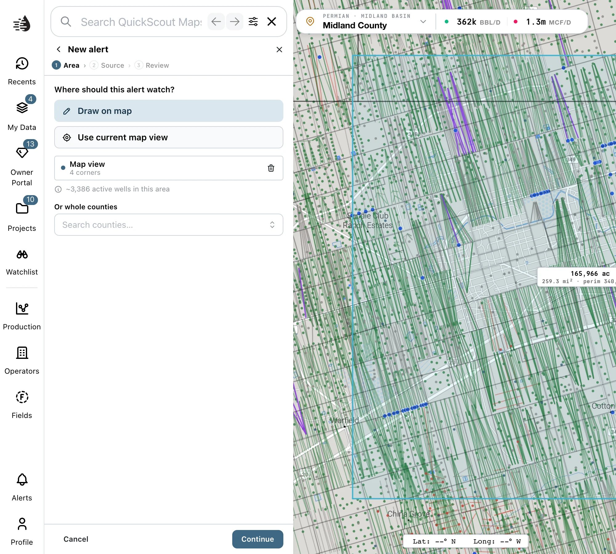
The editor takes three steps: **Area**, **Source** and **Review**. **Continue** moves on once a step is complete, and **Back** goes back.
Add one or more areas. They're watched together as one.
* **Draw on map**: click to place each corner, then double-click to close the shape. To change a shape afterwards, click it on the map and drag its corners.
* **Use current map view**: adds the part of the map you can see, a little inside its edges, as an area named *Map view*. Frame the map first.
* **Or whole counties**: search for counties and pick them. Use this instead of drawing to watch a county line exactly.
Each area is listed with its name (*Area 1*, *Map view*) and its corners. The trash icon removes it. Underneath, QuickScout estimates how many active wells the area holds.
## Create an alert
Click **New** at the top of the drawer. If you have no alerts yet, click **New alert**.
The editor takes three steps: **Area**, **Source** and **Review**. **Continue** moves on once a step is complete, and **Back** goes back.
Add one or more areas. They're watched together as one.
* **Draw on map**: click to place each corner, then double-click to close the shape. To change a shape afterwards, click it on the map and drag its corners.
* **Use current map view**: adds the part of the map you can see, a little inside its edges, as an area named *Map view*. Frame the map first.
* **Or whole counties**: search for counties and pick them. Use this instead of drawing to watch a county line exactly.
Each area is listed with its name (*Area 1*, *Map view*) and its corners. The trash icon removes it. Underneath, QuickScout estimates how many active wells the area holds.
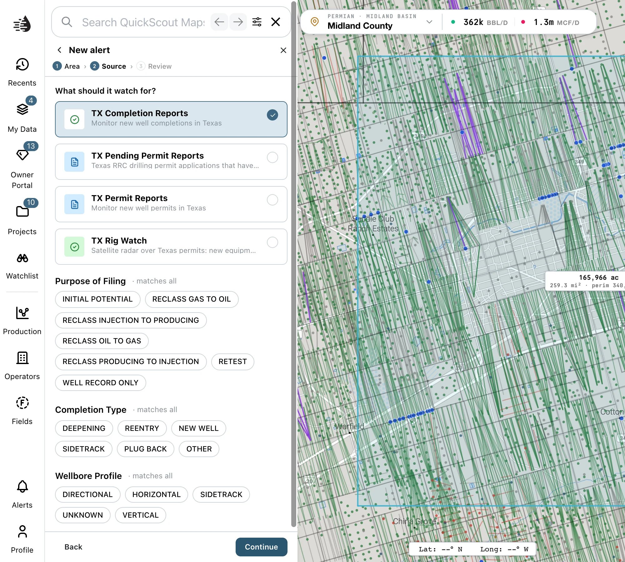
 Pick one source:
| Source | Watches for | Filters |
| ----------------------------- | ----------------------------------------------------------------------------------------------------------------------------------------------------------------- | ----------------------------------------------------------------------------------------------------------------------------------------------------------------------------- |
| **TX Permit Reports** | New drilling permits, once the RRC approves them. | **Well Type** (Oil Well, Gas Well, Injection…) and **Completion Type** (Drill, Recompletion, Re-enter…) |
| **TX Pending Permit Reports** | Permit applications that have been filed but not yet approved: the earliest sign of a new well. | **Well Type** (Horizontal, Vertical, Directional, and their sidetracks) |
| **TX Completion Reports** | New well completions, including initial potential tests. | **Purpose of Filing** (Initial Potential, Retest, reclassifications…), **Completion Type** (New Well, Deepening, Sidetrack…) and **Wellbore Profile** (Horizontal, Vertical…) |
| **TX Rig Watch** | What satellite radar sees at permitted sites: equipment arriving, drilling reported, equipment gone. Covers the counties [Rig Watch](/maps/layers#wells) watches. | **Event** (`arrived`, `drilling_reported`, `gone`), **Only when the records back it** (`drilling`, `drilling_likely`, `frac`) and **Minimum new metal (pixels)** |
Click the chips under a filter to choose values. A filter with nothing chosen *matches all*; **Clear** empties it.
Below the filters, a line checks your choices against filings already on record: *These filters match existing filings*, or *No filings match these filters yet*. The second isn't an error; it means nothing like that has been filed in the past, so the alert may be quiet.
Pick one source:
| Source | Watches for | Filters |
| ----------------------------- | ----------------------------------------------------------------------------------------------------------------------------------------------------------------- | ----------------------------------------------------------------------------------------------------------------------------------------------------------------------------- |
| **TX Permit Reports** | New drilling permits, once the RRC approves them. | **Well Type** (Oil Well, Gas Well, Injection…) and **Completion Type** (Drill, Recompletion, Re-enter…) |
| **TX Pending Permit Reports** | Permit applications that have been filed but not yet approved: the earliest sign of a new well. | **Well Type** (Horizontal, Vertical, Directional, and their sidetracks) |
| **TX Completion Reports** | New well completions, including initial potential tests. | **Purpose of Filing** (Initial Potential, Retest, reclassifications…), **Completion Type** (New Well, Deepening, Sidetrack…) and **Wellbore Profile** (Horizontal, Vertical…) |
| **TX Rig Watch** | What satellite radar sees at permitted sites: equipment arriving, drilling reported, equipment gone. Covers the counties [Rig Watch](/maps/layers#wells) watches. | **Event** (`arrived`, `drilling_reported`, `gone`), **Only when the records back it** (`drilling`, `drilling_likely`, `frac`) and **Minimum new metal (pixels)** |
Click the chips under a filter to choose values. A filter with nothing chosen *matches all*; **Clear** empties it.
Below the filters, a line checks your choices against filings already on record: *These filters match existing filings*, or *No filings match these filters yet*. The second isn't an error; it means nothing like that has been filed in the past, so the alert may be quiet.
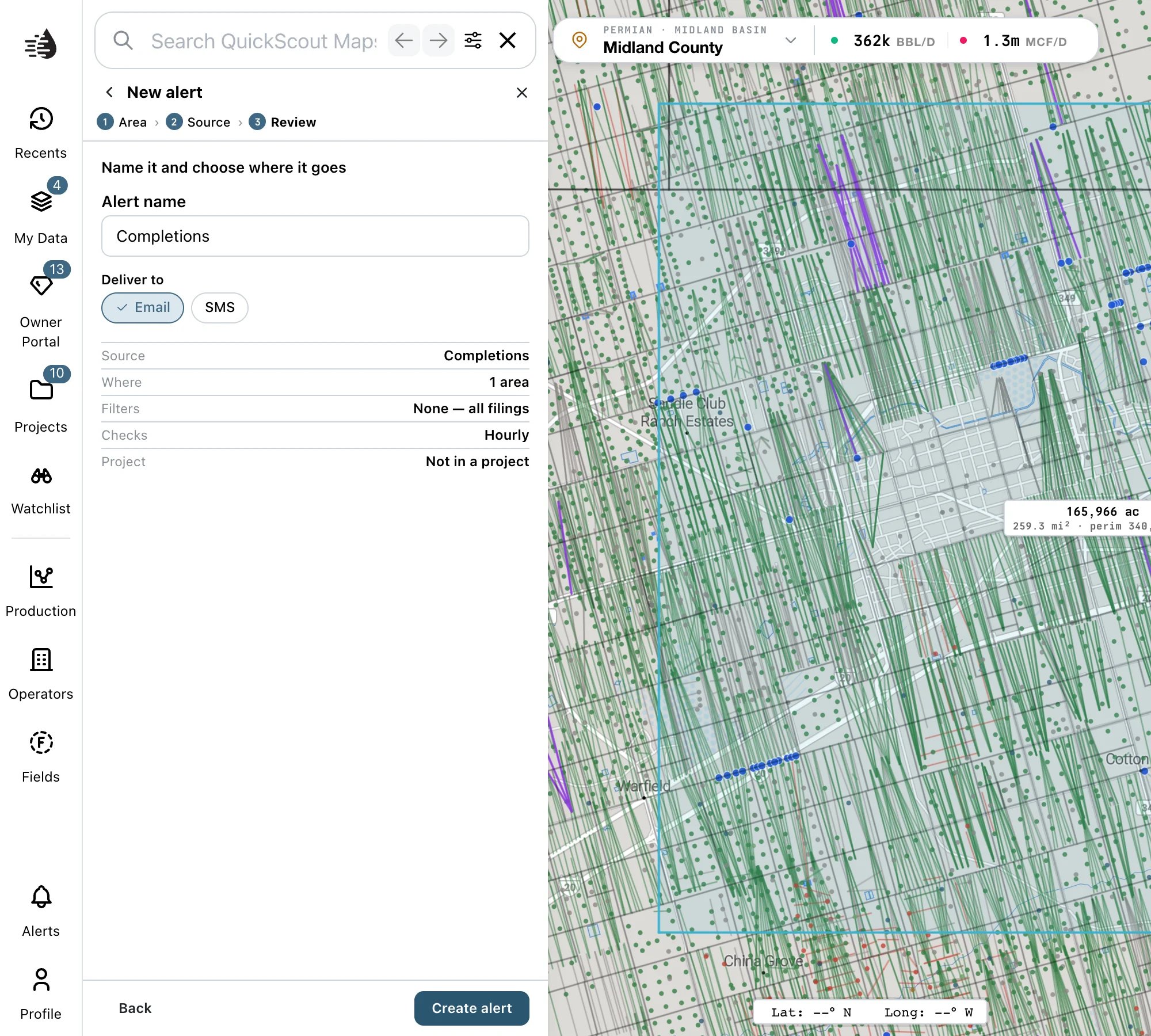
 * **Alert name**: starts as the source's name, such as *Completions*. Give it a name you'll recognize in your inbox, like *Martin County horizontal permits*.
* **Deliver to**: **Email** (on at first), **SMS**, or both. Texts go to the phone number on your QuickScout account.
The summary shows the **Source**, **Where** (for example *1 area · 3 counties*), how many **Filters** are set, and **Checks**: **Hourly**.
Click **Create alert**. The alert starts checking right away, and its first run lands within the hour.
* **Alert name**: starts as the source's name, such as *Completions*. Give it a name you'll recognize in your inbox, like *Martin County horizontal permits*.
* **Deliver to**: **Email** (on at first), **SMS**, or both. Texts go to the phone number on your QuickScout account.
The summary shows the **Source**, **Where** (for example *1 area · 3 counties*), how many **Filters** are set, and **Checks**: **Hourly**.
Click **Create alert**. The alert starts checking right away, and its first run lands within the hour.
 One alert watches one source. To follow a well from application to completion, create an alert for each source over the same area: **TX Pending Permit Reports**, **TX Permit Reports**, **TX Rig Watch** and **TX Completion Reports**.
## Your alerts
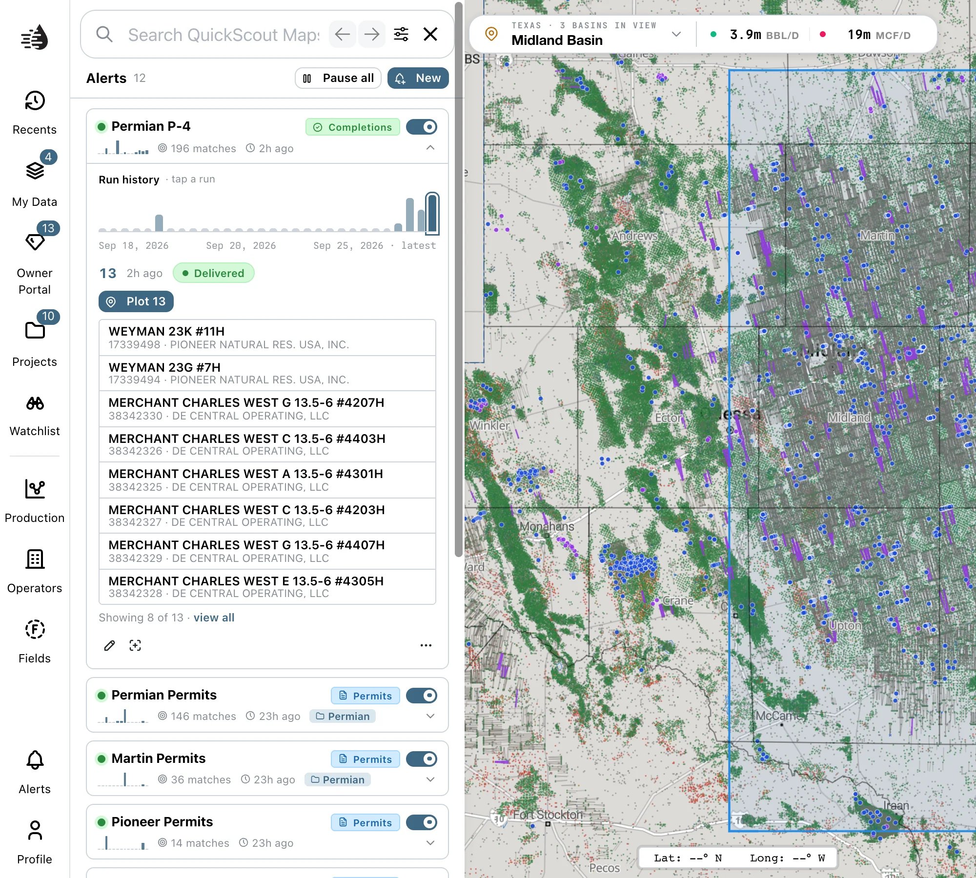
The drawer lists every alert, most recently active first. Each row shows:
* Its name, and a tag for its source, such as **Permits** or **Completions**.
* A 14-day chart of matches, how many it has found in the last 30 days, and when it last found something.
* A switch to pause it (**Pause alert**) or turn it back on (**Resume alert**). A paused alert is dimmed and marked **PAUSED**.
**Pause all**, at the top, pauses every alert without deleting any. When all of them are paused, it reads **Resume all**.
A number on the **Alerts** button in the rail counts the alerts that have found something since you last opened the drawer.
### See what an alert found
Click an alert to expand it. The map outlines its area in blue and flies there.
* **Run history** has a bar for each of the last 30 runs, sized by how many matches it found. Click a bar to see that run. A run is **Delivered**, found **No matches**, or **Failed**.
* The run's matches are listed underneath: the lease and well number, API, operator and county. **Click a match** to open the well's record.
* **Plot N** puts the run's matches on the map as blue pins and frames them. Hover a pin for the well, or click it to open the record. **Re-frame** frames them again after you've moved the map.
* When a run found more than eight wells, click **view all**.
### View all, and export
**view all** opens the run's full results in **Replay**:
* **MATCHES**, **EXECUTION** time and **STATUS** across the top.
* Breakdowns **By operator**, **By field** and **By county**, and the average **Lateral length**.
* Every result in a table. **Filter results…** narrows it, and **Export CSV** downloads the rows you're looking at.
Replay shows the results stored when the alert ran. It doesn't run the search again.
### Edit, duplicate and delete
On an expanded alert:
* The pencil (**Edit alert**) reopens the three steps. You can change the name, areas, counties, filters and where it's delivered. The **source** can't be changed; create a new alert for that.
* The crosshair zooms to the alert's area.
* **⋯** has **Duplicate** and **Delete**.
**Duplicate** makes an active copy named *‹name› (copy)*. Change its area or filters: two identical alerts aren't allowed.
**Delete** asks first, then gives you about six seconds to **Undo**. The alert's run history is kept.
## Limits
* Up to **50** active alerts. Pause or delete one to make room.
* Alerts check **hourly**. That can't be changed.
* Operator transfers (P-4s), frac jobs and satellite pads aren't sources yet.
## Troubleshooting
Each step needs something before you can move on:
* **Area**: at least one area or county.
* **Source**: a source.
* **Review**: a name (*Give this alert a name*) and at least one of **Email** or **SMS** (*Pick at least one way to be notified*).
The visible part of the map is too narrow, usually because the data tables are wide open. Close or narrow the tables, then try again.
You already have an alert with the same source, area and filters. Change a filter or the area.
Pause or delete an alert you no longer need, then save again.
* Expand it and look at **Run history**. *No runs yet* means the first run is still due, within the hour.
* Runs marked **No matches** mean nothing new was filed in the area. Widen the area, or clear a filter.
* Check it isn't **PAUSED**.
* Texts go to the phone number on your QuickScout account. If none is on file, choose **Email**.
Some older alerts were saved in a format the editor can't redraw. Draw the area again, then **Save changes**.
## The Alerts page
Every alert you create in Maps also appears on the separate [Alerts page](/tools/alerts), which lists all their matches together, and the other way round.
One alert watches one source. To follow a well from application to completion, create an alert for each source over the same area: **TX Pending Permit Reports**, **TX Permit Reports**, **TX Rig Watch** and **TX Completion Reports**.
## Your alerts
The drawer lists every alert, most recently active first. Each row shows:
* Its name, and a tag for its source, such as **Permits** or **Completions**.
* A 14-day chart of matches, how many it has found in the last 30 days, and when it last found something.
* A switch to pause it (**Pause alert**) or turn it back on (**Resume alert**). A paused alert is dimmed and marked **PAUSED**.
**Pause all**, at the top, pauses every alert without deleting any. When all of them are paused, it reads **Resume all**.
A number on the **Alerts** button in the rail counts the alerts that have found something since you last opened the drawer.
### See what an alert found
Click an alert to expand it. The map outlines its area in blue and flies there.
* **Run history** has a bar for each of the last 30 runs, sized by how many matches it found. Click a bar to see that run. A run is **Delivered**, found **No matches**, or **Failed**.
* The run's matches are listed underneath: the lease and well number, API, operator and county. **Click a match** to open the well's record.
* **Plot N** puts the run's matches on the map as blue pins and frames them. Hover a pin for the well, or click it to open the record. **Re-frame** frames them again after you've moved the map.
* When a run found more than eight wells, click **view all**.
### View all, and export
**view all** opens the run's full results in **Replay**:
* **MATCHES**, **EXECUTION** time and **STATUS** across the top.
* Breakdowns **By operator**, **By field** and **By county**, and the average **Lateral length**.
* Every result in a table. **Filter results…** narrows it, and **Export CSV** downloads the rows you're looking at.
Replay shows the results stored when the alert ran. It doesn't run the search again.
### Edit, duplicate and delete
On an expanded alert:
* The pencil (**Edit alert**) reopens the three steps. You can change the name, areas, counties, filters and where it's delivered. The **source** can't be changed; create a new alert for that.
* The crosshair zooms to the alert's area.
* **⋯** has **Duplicate** and **Delete**.
**Duplicate** makes an active copy named *‹name› (copy)*. Change its area or filters: two identical alerts aren't allowed.
**Delete** asks first, then gives you about six seconds to **Undo**. The alert's run history is kept.
## Limits
* Up to **50** active alerts. Pause or delete one to make room.
* Alerts check **hourly**. That can't be changed.
* Operator transfers (P-4s), frac jobs and satellite pads aren't sources yet.
## Troubleshooting
Each step needs something before you can move on:
* **Area**: at least one area or county.
* **Source**: a source.
* **Review**: a name (*Give this alert a name*) and at least one of **Email** or **SMS** (*Pick at least one way to be notified*).
The visible part of the map is too narrow, usually because the data tables are wide open. Close or narrow the tables, then try again.
You already have an alert with the same source, area and filters. Change a filter or the area.
Pause or delete an alert you no longer need, then save again.
* Expand it and look at **Run history**. *No runs yet* means the first run is still due, within the hour.
* Runs marked **No matches** mean nothing new was filed in the area. Widen the area, or clear a filter.
* Check it isn't **PAUSED**.
* Texts go to the phone number on your QuickScout account. If none is on file, choose **Email**.
Some older alerts were saved in a format the editor can't redraw. Draw the area again, then **Save changes**.
## The Alerts page
Every alert you create in Maps also appears on the separate [Alerts page](/tools/alerts), which lists all their matches together, and the other way round.